El Nino Southern Oscillation (ENSO)
During mid-August 2016 the Tropical Pacific Sea Surface Temperature (SST) anomaly was close to -0.5oC, approaching the weak La Nina threshold. However, most key atmospheric variables continue to indicate neutral ENSO conditions. Although the upper level winds in the Tropical Pacific are slightly suggestive of La Nina, the lower level winds remain near average. The Southern Oscillation index and the pattern of cloudiness and rainfall in the Equatorial Pacific also indicate neutral ENSO despite a mild tilt towards La Nina. The collection of ENSO prediction models indicate SSTs most likely near the borderline of cool-neutral and weak La Nina from the present through to the end of the 2016 Wet/ Hurricane Season and into the 2017 Dry Season.
Expected Impacts on Rainfall and Temperatures
A shift towards above to normal rainfall is noted for much of the Caribbean towards the end of the year due to slightly reduced winds in the upper atmosphere. This reduction allows for stronger, local showers to develop. A higher frequency of tropical storms during La Nina also can contribute to higher rainfall totals.
Climate conditions in the Tropical North Atlantic and Caribbean
Recent observations showed SSTs at 0.5-1oC above-average within the Caribbean and the Tropical North Atlantic. Trade winds were calmer than usual.
Expected Conditions: Slight positive SST anomalies are expected throughout the Tropical North Atlantic by September-October-November and December-January-February. Tradewind strengths are hardly predictable at seasonal time scales.
Expected impacts: Warm Atlantic temperatures increases evaporation and local deep atmospheric convection, potentially increasing precipitation. Average circulation patterns during La Nina periods may also contribute to increased frequency of developing tropical storms.
Note: Until the end of September, intrusion of dust and dry air associated with the Saharan Air Layer (SAL) and the trade winds may decrease rainfall chances. This is hardly predictable at seasonal time scales.
Regional Overview on Seasonal Forecasts for September to November 2016
Rainfall Outlook

Rainfall total for the period September -October- November 2016 for Dominica is forecast to be slightly below normal to normal.
Probability:
- 25% chance of above normal
- 35% chance normal
- 40% chance of below normal
Wet Days and Wet Spells Outlook
Wet Days

| Station | Climatology (Wet days) | Forecast (Wet days) |
|---|---|---|
| Canefield Airport | 42 to 54 | 40 to 56 |
| Douglas-Charles | 57 to 70 | 50 to 67 |
Forecast: Fewer wet days than normal (medium to high confidence).
Implication: Continued disruption of outdoor activities due to regular rainfall events but less frequent than usual.
7-Day Wet Spells

| Station | Climatology (7 day wet spell) | Forecast (7 day wet spell) |
|---|---|---|
| Canefield Airport | 3.0 to 5.9 | 2.4 to 6.4 |
| Douglas-Charles | 3.9 to 6.0 | 3.9 to 7.4 |
Forecast: Fewer 7-day wet spells (medium confidence) and fewer 7-day very wet spells (low confidence).
3-Day Wet Spells

| Station | Climatology (3 day extreme wet spell) | Forecast (3 day extreme wet spell) |
|---|---|---|
| Canefield Airport | 0 to 2.0 | 0 to 2.3 |
| Douglas-Charles | 0 to 1.3 | 0 to 2.3 |
Forecast: An increase in numbers of 3-day extreme wet spells (medium confidence).
Implication: Flash flood potential developing.
Drought Outlook

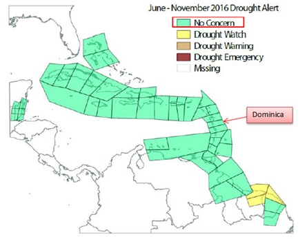
There are no drought concerns for Dominica both at the short term (June - November 2016) and long term (December 2015 - November 2016).
Temperature Outlook

Air temperatures are expected to be above to normal. Night and day-time temperatures are expected to be warmer.
Minimum/night-time temperature Probability
- 70% chance of above normal
- 20% chance normal
- 10% chance of below normal
Maximum/day-time temperature Probability
- 55% chance of above normal
- 30% chance normal
- 15% chance of below normal


